Siirt Province
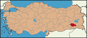
Siirt (Arabic: سِعِرْد, Siġird; Armenian: Սղերդ, Sgherd; Kurdish: Sêrt;) is a province of Turkey, located in the southeast. The province borders Bitlis to the north, Batman to the west, Mardin to the southwest, Şırnak to the south, and Van to the east. It has an area of 5,406 km² and a total population of 266,159. The population was 263,676 in 2000. Arabs and Kurds form the majority. There is also a minority of Assyrians living in the area. [1] The provincial capital is Siirt.
Districts
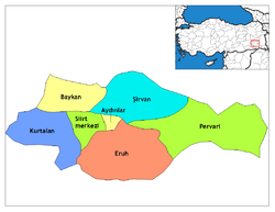
Siirt province is divided into 7 districts (capital district in bold):
- Aydınlar
- Baykan
- Eruh
- Kurtalan
- Pervari
- Siirt
- Şirvan
Notes
External links